THANKS FOR RUNNING' WITH THE BIG DAWG!
CATCH
WAKE UP WITH LARRY SMITH AT 5 A.M. FOR “MORNINGS ON MAIN” ON 99.9 THE BIG DAWG!

Forgot Password

Not a Member? Sign up here!

BIG DAWG WEATHER

Heavy Rain/Severe Weather Potential Increasing

The Big Dawg Weather Blog is presented by:


Good Tuesday Afternoon, Folks! Widespread moderate to heavy rainfall is likely Thursday evening through early Saturday morning. Total rainfall amounts of 2-4 inches are possible through Saturday, though thunderstorms could contribute to localized swaths of 4+ inches of rain. This rain will increase the risk of flash flooding and minor to moderate river flooding. 

NWS Rainfall Forecast 

In addition to the heavy rain threat, strong to severe storms are possible Friday afternoon, with the best chances across southern Kentucky. The SPC currently has areas to our south highlighted as the best opportunity for severe weather, but I suspect this will expand into our area in later forecasts.

SPC Friday Outlook 

As always, Ill be watchig things closly, stay weather aware in the coming days! 


Severe Weather Chances Ramp Up

The Big Dawg Weather Blog is presented by:

Good Tuesday Afternoon, Folks! I wanted to give everyone an update on what to expect over the next 48 hours, which looks to be a very active period! 

Tonight through Tomorrow Morning

  • Strong south winds 20-30 mph with gusts 40-50 mph this evening
  • Localized gusts above 50 mph possible
  • Timing of highest wind gusts will be from 7 PM EST to 1 AM EST tonight
  • Loose outdoor items will be blown around, and small limbs could fall
  • Isolated power outages possible Travel in high profile vehicles could be difficult, especially on W to E oriented roadways

Wednesday Night through Thursday Morning

The first chance for severe weather comes Wednesday night into early Thursday. Scattered storms will move into our area from western Tennessee. The strongest storms look to remain west of I-65, just out of our immediate area, but strong storms are still possible. Generally, I'm not looking at a significant severe weather risk here, but strong to an isolated severe storm is possible! 

Thursday Afternoon

This is the period that Im watching the most. This setup looked much worse a few days ago, but thankfully things didn't play out as they could have. However, we are still looking at a good chance of severe weather during the afternoon period on Thursday, and we all know how mother nature is; you never know what you will get. So it's essential to be prepared for the worst and hope for the best!

  • Time Period 12PM- 7PM Eastern 
  • All severe hazards are on the table, but main threat is damaging winds and hail

  • Short-Lived Tornadoes are on the table 

  • Gusty winds outside of showers and storms

  • Stay up to date on the latest forecasts

The SPC has placed the entire area in a SLIGHT risk for severe weather, which means that scattered severe storms are possible. 


As always, I'll be monitoring things closely! LIVE video is planned for tomorrow (Wednesday, Feb 15th), at 5 PM Central/6 PM Eastern! 
Have a wonderful afternoon, and I'll be chatting with you soon! 


All Eyes on Thursday

The Big Dawg Weather Blog is presented by:

Good Saturday afternoon, Folks! I only have a short blog post with a few details, but I want to discuss the potential for severe weather in our area on Thursday. Looking at the data, we will see an area of low pressure bring moisture into the Ohio/Tennessee valleys by Wednesday night, resulting in some gusty winds and storm chances. Thursday is the day I have my eyes on; as a cold front approaches our area, a round of severe weather looks likely across the Mississippi, Ohio, and Tennessee Valleys. All the ingredients necessary for a significant severe weather outbreak will be present; however, there remain questions on the overall setup and track. Once these questions clear up, there will likely be upgrades to the current Storm Prediction Center Outlook that I have posted below.  

SPC Thursday Outlook 

I'll be watching things closely, but in the meantime, don't freak out or start worrying. We are still in "watch and see" mode. The best advice I can give is don't be scared, and be prepared! 
Have a good Saturday, and I could have a LIVE tomorrow or Monday. 

Winter Weather Potential Increasing

The Big Dawg Weather Blog is presented by:

Good Saturday Afternoon, Folks! I was planning to do a live video today, but the data is still rather messy; therefore, I decided to type up a quick blog explaining what we could deal with next week. The bottom line is that we will see multiple chances for wintry weather from Monday night through Thursday, with ice or snow accumulations possible.

Key Messages 

  • The best chance for Wintry Weather is on Tuesday, with more waves of wintry precipitation on Wednesday and Thursday. 
  • Ice accumulation is the main threat that we are looking at here in Central Kentucky. 
  • Amounts are still unknown, but even a little Ice can have significant impacts. 
  • Some snow is possible, but that will be mainly to our north. 
  • The Forecast will change over the next few days; stay tuned. 

On Tuesday, the NWS highlighted Central Kentucky with the greatest potential in Louisville's area to see impacts from potential Ice accumulations. 

I will provide updates more frequently over thew weekend, and I will provide a LIVE video tomorrow to address all the newest data. Stay weather aware over the next few days! 


Wintry Weather Increases

The Big Dawg Weather Blog is presented by:

Good Monday Evening, Folks! An area of low pressure is expected to pass over the state Tuesday night, bringing precipitation chances to our area. As of this blog post, a wintry mix is possible tomorrow night, changing to rain during the day on Wednesday. The best chances for accumulating Snowfall through Wednesday will be along and north of the Ohio River. Additionally, gusty winds of 30 to 40 mph will be possible during the day Wednesday.

As we progress into Wednesday Night and Thursday morning, temperatures will drop again, changing rain to snow. Snow squalls are possible across the state, producing a quick half inch of snow with any snow squall. Ill be monitornig things closly over the coming days, stay tuned! 

Another Active Weather Week Ahead

The Big Dawg Weather Blog is presented by:

Good Sunday night, everyone! We will look at two waves of rainfall this week, with the first coming tomorrow night into Tuesday. Showers and a few thunderstorms will bring heavy rainfall again on
Wednesday night, especially across south central Kentucky. Rainfall amounts up to 2 inches could result in localized flooding of low-lying areas, and subsequent river flooding.

The latest GFS model is showing 2-3 inches of rain possible before the week is over. 

GFS Forecast Rainfall through Thursday Night 


As aways, Ill be monitoring this weeks weather, and Ill provide updates as needed! Have a great week! 


Storms/Snow Likely Thursday and Friday

The Big Dawg Weather Blog is presented by:


Good evening, Folks! Scattered showers and thunderstorms are expected early tomorrow morning and lasting into the early afternoon ahead of a cold front. A few of the storms may become severe during the morning hours. The main threat with severe storms will be isolated damaging wind, brief heavy rainfall, and possible hail. A tornado or two cannot be ruled out either. This isn't a significant severe weather threat, but we must watch any severe threat closely. The SPC has placed the entire area in the lowest severe weather risk. 

SPC OUTLOOK


Temperatures will drop Thursday night, bringing scattered snow showers to the area on Friday. Minor snow accumulations under 1 inch are possible at this time, but Ill keep an eye on this. 

Ill be monitoring things closly, stay tuned for updates! 

Storms/Rain Likely Next 48 Hours

The Big Dawg Weather Blog is presented by:


Good Evening, Folks! I wanted to give everyone a quick update on what to expect over the next 48 hours! Multiple rounds of showers and storms will impact the region late tonight through early Wednesday morning. 

Tonight

Isolated instances of severe weather will be possible during the overnight period. If severe weather does occur, damaging straight-line winds are most likely in the storms, with small hail and an isolated tornado possible. However, tonight's severe threat is extremely low. The SPC doesn't have our area at risk for severe storms tonight. 

Tuesday 

Storms will continue throughout the day on Tuesday, and below is the latest breakdown: 

  • One round of showers and a few storms Tuesday morning, then another round late Tuesday night.
  • The best chance for storms Tuesday night is between midnight and dawn.
  • Damaging straight-line winds, small hail, and an isolated tornado are possible.
  • Outside of storms, gusty southerly winds of 30 to 40 mph will be possible Tuesday.
  • Minor flooding may develop in spots that see the heaviest rainfall.

The SPC does highlight our area for the possibility of severe weather, but again, it is a low risk. 

In addition to the severe storm threat, Widespread 1.5” to 3” expected with locally higher amounts. Localized minor flooding will be possible. 

As with any severe weather threat, we must always be on our toes. I'll be monitoring things closely and will give updates as needed! Stay tuned


Winter Storm Potential Increasing

The Big Dawg Weather Blog is presented by:

Good Sunday Evening, Folks! We continue to track a strong weather system that will impact the region Thursday and into the holiday weekend. Here is the breakdown 

  • Accumulating snow likely Thursday night and into Friday morning. (Amounts to be determined) 
  • Dangerously cold temperatures and wind chills expected for Friday and Saturday mornings.
  • Wind chills of -10 to -20 will be possible Friday and Saturday mornings. 
  • Wind gusts of 45-50 mph will be possible late Thursday night and Friday morning.

DANGEROUS COLD

One thing I want us to keep track of is the dangerously cold temperatures heading our way. Low Temperatures Fri and Sat will be at or approaching 0, with wind chills -10 to -20. This is very dangerous, and if you know anyone in the area who may struggle to keep warm, now would be the time to help them out in any way we can. I expect Wind Chill Warnings or Advisories for our area with this setup. 

Forecast Models 

I will not post all the forecast models to save time, but the GFS model is below. The other models show something similar; they just differ on the track. You guys know the drill here; if it's a track to the north, we would see lesser amounts; if it tracks more south, our snowfall would be higher. Right now, several inches is likely. 

Bottom Line

This will be a HIGH IMPACT event for much of the state. Rain will overspread the area on Thursday; as the colder arctic air crashes into the area Thursday night, the rain will quickly change to snow. The snow could become heavy at times. 

If you have travel plans for later this week, please monitor forecasts closely over the next few days.


Saturday Evening Update

The Big Dawg Weather Blog is presented by:


An Arctic cold front is expected to move into the Ohio Valley sometime Thursday. This front will bring much colder temperatures and windy conditions, making for dangerously cold wind chills. In addition, there is increasing confidence in snow moving into the region Thursday, possibly impacting holiday travel plans.

There is still no reason to get too excited just yet because we are still 5-6 days away; however, the threat of accumulating snowfall across our area for next week is increasing. 

Below are my latest thoughts:

GFS Forecast Model 

The latest update from the GFS model has shifted the storm to the Northwest, which also shifts the heaviest snow into Indiana. However, it still gives our area a decent snowfall by the end of the week. 

EURO Forecast Model

The European model has the right overall theme but is weaker and much further north. This would only give our area an inch or two. 

Canadian Forecast Model

The Canadian model is similar to the GFS and gives our area several inches. 

Bottom Line

We will have a decent idea of what to expect from this storm system by Monday—accumulating snow just before Christmas is a good bet, with heavy snow potentially on the table. There are still a TON of details that need to be resolved, so let's continue to monitor the latest trends and stay calm. 

Ill keep you all up to date with the latest, enjoy the evening!


Thursday Evening Update

The Big Dawg Weather Blog is presented by:

Good Afternoon, Folks! I know that most of you are dying for an update on the potential for some winter weather next week, so let's dig into the latest!

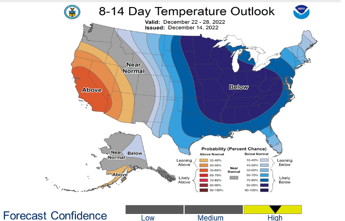
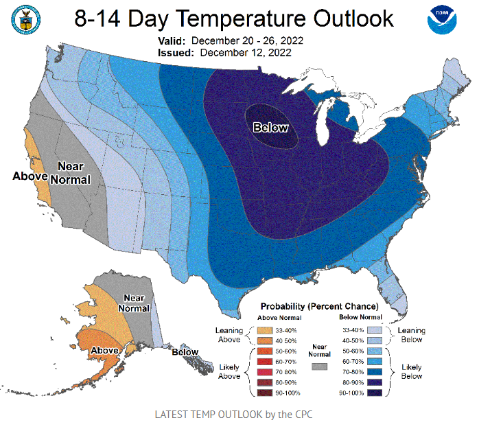
Bitterly cold air is expected to arrive in the Ohio Valley late next week. This cold air will remain in place through the Christmas holidays. Temperatures next weekend may be some 20-30 degrees below normal for late December. Some wintry weather may accompany the arrival of the cold air. However, that portion of the forecast needs to be determined. 

On Monday, I mentioned that our area would have arctic air, and we just needed a storm to take the right track for our region to see accumulating snow. We have the arctic air and a storm to track; we just need this storm to take the right track. 

8-14 Day Temperature Outlook

In the next 2-3 days, we will be in "monitoring mode." This means there is the potential for accumulating snow next week, but please keep in mind we are 6-8 days away, and plenty of things change. So let's keep our emotions in check (especially if you are a snow lover) because there will be swings in the data as it tries to sort out all the details. 
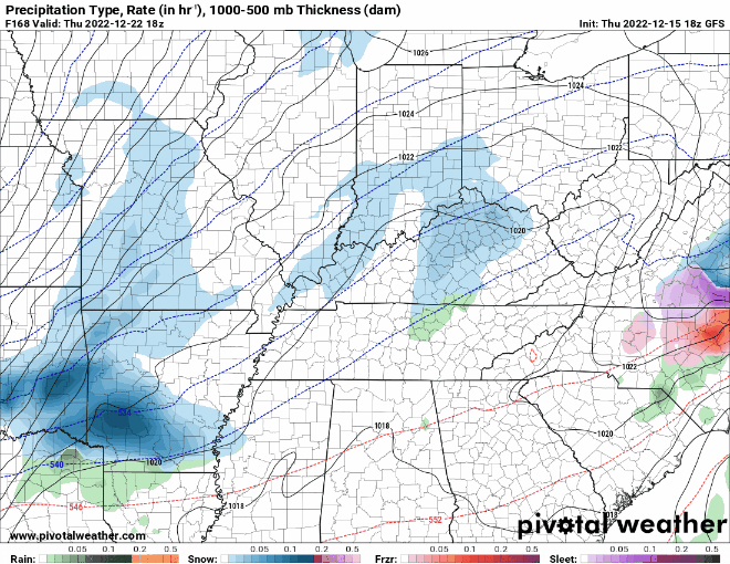
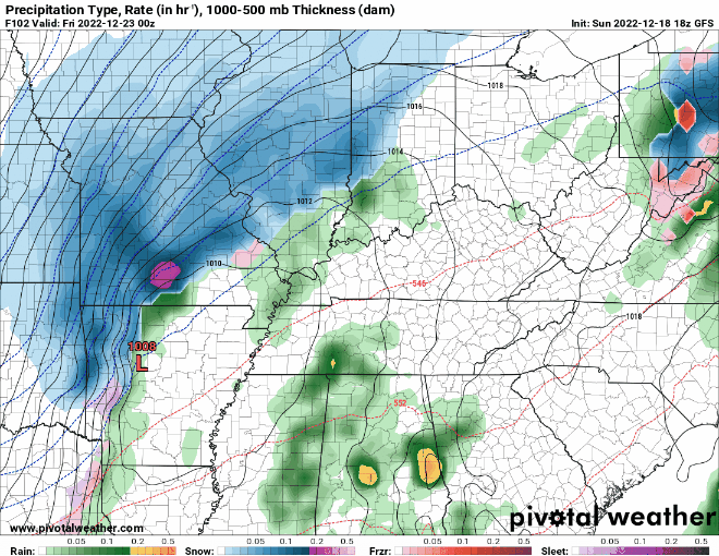
 

GFS Forecast Model 

The GFS model has a significant storm system that would impact our area in around 6-7 days, around Thursday, December 22nd. 
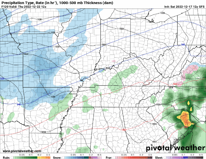
EURO Forecast Model

The EURO model shows a similar forecast but with a weaker system. 

Canadian Forecast Model

The Canadian model shows absolutely nothing for our area next week.

Bottom Line

Again, we are still early in the game here, folks. So, let's temper our expectations until the forecast can become more precise. However, I think our chances for accumulating snowfall are increasing, and it may be our best chance at a white Christmas since 2010. As always, ill be motioning things much closer than I usually do, and I'll post updates as needed! Stay tuned! 


Monday Evening Update

The Big Dawg Weather Blog is presented by:


Good Afternoon, Folks! Thunderstorms with locally heavy rainfall will be possible Tuesday night through Wednesday night. A localized, minor flooding threat cannot be ruled out. 1-2 inches of rain is possible during this timeframe. 

The big story that everyone is interested in is the pattern change that will take place during the second half of December. Almost all of the latest data suggests that cold arctic air will overtake much of the central/eastern U.S. Once you have cold air in place, you need a storm system to bring precipitation into the arctic air zone. We are still determining how far south this arctic air will track. If it's further north, our snow chances, locally, would be lower. If the cold arctic air is further south, our snow chances would be higher. Long story short, I only have a little information for you. But if you are hoping for snow on Christmas week, the first thing we need is Arctic air, and it appears we will have that. I will be watching things closely, and ill keep everyone updated as we progress closer and details become clearer! 


Changes Coming

The Big Dawg Weather Blog is presented by:


Good Afternoon, Folks! It's officially time to fire the blog back up as we head into winter! The blog will be updated at least once a week, with more posts if the weather is active!
Multiple rounds of rainfall are expected through early Friday. The heaviest rains are likely Thursday into Thursday night and could result in localized flooding.
I am monitoring a more significant storm system that will impact our area next week, which has the potential to produce strong storms while transitioning to isolated snow showers. The latest Canadian model shows that exact scenario: a line of solid storms followed by some light snow. It's hard to say how intense these storms will be or if any snow showers will accumulate. Both look unimpressive, but it's something to watch as we progress toward next week. I'll keep everyone updated, have a good evening!     


Flood Watch In Effect

The Big Dawg Weather Blog is presented by:


Flood Watch has been issued, which is in effect through Monday evening. Thunderstorms will produce locally heavy rainfall, especially during the afternoon and evening hours. Excessive runoff may flood rivers, creeks, streams, and other low-lying and flood-prone locations. This may cause creeks and streams may rise out of their banks. Stay up-to-date with the latest weather developments and be prepared to seek higher ground if flooding threatens.

Flood Watch Map 


Another Flood Watch in Effect

The Big Dawg Weather Blog is presented by:

Flood Watch in Effect from 8 AM EDT Friday through Friday Evening. Excessive runoff may result in flooding of rivers, creeks, streams, and other low-lying and flood-prone locations. Creeks and streams may rise out of their banks. Rainfall amounts of 1 to 2 inches are possible on Friday. Slow-moving showers and thunderstorms that repeatedly move over the same areas could easily produce localized swaths of higher rainfall totals.


Flood Watch Now in Effect

The Big Dawg Weather Blog is presented by:

Flood Watch is now in effect from Sunday Morning through Monday Morning. Excessive runoff may flood rivers, creeks, streams, and other low-lying and flood-prone locations.
Periods of showers and thunderstorms are expected across the watch area. Rainfall rates of 1-2 inches per hour will be possible and bring a flash flood threat to central and southern Kentucky Sunday and Sunday night portions. Areas that see repeated rounds of thunderstorm activity will be most susceptible to flash flooding. You should monitor later forecasts and be alert for possible Flood Warnings. Those living in areas prone to flooding should be prepared to take action should flooding develop.

Flooding Threat Set to Increase Again

The Big Dawg Weather Blog is presented by:

Good Friday Afternoon, Folks! Parts of Eastern Kentucky have witnessed historic flooding over the past few days, and they are still on guard for additional flooding today through Tuesday. Most of the state will see the flood threat increase again, beginning Saturday night Through Tuesday. Showers and thunderstorms are expected to increase in intensity on Sunday. Multiple rounds of persistent heavy rainfall could cause isolated flooding concerns. WKYT in Lexington has highlighted much of Central and Southern Kentucky for the highest Flooding threat Sunday through Tuesday! We will keep you updated over the weekend, but it's important to stay weather aware, especially if you live in flood-prone or poor drainage areas! 

Flash Flood Threat from WKYT 


Hot Weekend on the Way

he Big Dawg Weather Blog is presented by:

Good Afternoon, Folks! Well-above normal temperatures are expected Saturday and Sunday. High temperatures will approach 100 degrees both days, with maximum heat indices likely to exceed 105 degrees. Prolonged exposure to this level of heat can pose health dangers, including heat exhaustion and heat stroke. If possible, limit time spent outdoors these days, and be sure to remain hydrated at all times.

Heat Wave with Severe Storm Threat

The Big Dawg Weather Blog is presented by:

Thunderstorms will be possible for much of this week, especially in the afternoon and evening. The main threats will be torrential rainfall, locally gusty winds, and lightning. The Storm Prediction Center has placed our area in a Marginal Risk (Level 1/5) for severe weather tomorrow and a Slight Risk (Level 2/5) for Wednesday. In addition to the storm chances, a combination of heat and humidity will create heat indices rising above 100 degrees, mainly from Tuesday through Thursday. As always, we will be watching things closely here in the Big Dawg Weather Center and will keep you updated with the latest. 

SPC Severe Weather Outlook for Tuesday    

SPC Severe Weather Outlook for Wednesday 

Drought Information 

Rainfall Potential Next 84 Hours 


Rain Likely Later Today

The Big Dawg Weather Blog is presented by:

Scattered thunderstorms are likely later today and tonight ahead of a cold front. Gusty winds, cloud-to-ground lightning, and brief heavy rainfall would be the main threats. Storms will be most active from 3 pm to midnight, especially south of I 64, with the most concentrated area south of the Blue Grass Parkway. Hopefully, mother nature will give us some much-needed rain; the GFS model shows the most concentrated rainfall in Southeastern Kentucky but also gives parts of central Kentucky at least some rain. 

GFS MODEL 

A very unsettled period of weather is expected Friday and Saturday. Scattered showers and storms are expected. Some of these will contain heavy rainfall. With next weekend being a holiday, I will monitor the latest forecast for you! Have an excellent Sunday, folks! 

Rain Chances Increasing

The Big Dawg Weather Blog is presented by:

Good Friday Afternoon, Folks! Scattered thunderstorms are expected later Saturday and Sunday into Sunday night ahead of a cold front. Some of these storms late on Sunday could be strong to severe. Gusty winds, cloud-to-ground lightning, and brief heavy rainfall would be the main threats. 

U.S. Drought Monitor

Looking at the U.S. Drought Monitor, much of the central and eastern portions of the state are abnormally dry, with parts of Central Kentucky already in a moderate drought. We need the rain, and much of the data shows some decent rainfall totals. 

GFS

EURO

Fingers crossed that we receive some much-needed rain this weekend. As always, I'll be monitoring our severe weather potential! Take care, and have a great weekend, folks! 


Dangerous Heat Expected This Week

The Big Dawg Weather Blog is presented by:

Good Sunday Afternoon, Folks! A few thunderstorms will be possible late tonight. Gusty winds and lightning will be the main threats if storms develop. Beginning tomorrow, hot afternoon temperatures in the 90s and increasing humidity will yield heat index values above 100 degrees by the early to mid-week time frame. In addition, a few strong to severe storms are possible Monday. Damaging wind or large hail will be the main threats if storms develop. With dangerous heat expected this week, below are some heat saftey tips! Now is the time to prepare for extreme heat. Check on your friends, family, and neighbors, especially the elderly. Make sure to know the signs of heat exhaustion and heat stroke and know what actions to take. Together, we can all stay safe!


Alert Day Issued for Wednesday

The Big Dawg Weather Blog is presented by:

Good Tuesday evening, Folks! Rounds of showers and storms will continue to impact our area for much of the week. Some isolated storms are possible this evening into tonight, but a better chance for strong to severe storms arrives tomorrow through tomorrow night. The main threat with any storm will be damaging winds and small hail. Heavy rainfall is also a concern, especially in areas that received several inches of rain last night. Flash Flooding is also a concern in flood-prone and poor drainage areas. The Storm Prediction Center has placed the entire state in a slight risk for severe weather tomorrow, which means scattered severe storms are possible.  

Ill keep you updated, stay weather aware throughout the day tomorrow! 


Rounds of Storms Expected this Week

The Big Dawg Weather Blog is presented by:

Good Sunday afternoon, Folks! Were looking at a stormy setup for the week, with thunderstorms, some strong to severe, occurring Monday afternoon into the overnight period. Damaging winds are the main threat, though an isolated tornado and/or small hail can not be ruled out. Localized flooding also is possible in areas that see persistent storminess late Monday night. Additional storms are forecast for Tuesday and Wednesday. A few of these storms could become strong to severe on Wednesday, with gusty winds and small hail as the main threats.

Heavy rainfall is a good bet with the southern half of the state seeing the best chance for heavier rain. Below is the WPC rainfall forecast over the next 5 days, areas in the darker purple and red could see between 2-3 inches of rain this week. I'll keep you updated on the latest! Have a great week, folks! 


Strong Storms/Heavy Rain Possible Thursday and Friday

The Big Dawg Weather Blog is presented by:

Good Evening, folks! Tonight, scattered thunderstorms could become strong, with locally damaging wind gusts as the main hazard. Lightning and hail are also possible; however, im expecting this to be a shallow threat. Thunderstorms will be possible on Thursday, and heavy rain could result in localized flooding in locations with repeated rainfall. Locally damaging winds and hail will also be possible in stronger storms. Showers and thunderstorms will continue into Friday; again, some strong storms with localized heavy rainfall are possible. The SPC has placed our area in a Marginal Risk for severe weather tonight and tomorrow, the lowest severe weather risk. This means that Isolated severe storms are possible but are limited in duration and intensity. 

The holiday weekend looks very lovely, with sunny conditions expected on Saturday (High 74), Sunday(High 82), and Monday(High 87). 

Have a great night, everyone! 

On Air Now

Regular Programming
6:00pm - 12:00am
Regular Programming

CNN News

Entertainment News

Twitter