THANKS FOR RUNNING' WITH THE BIG DAWG!
CATCH
WAKE UP WITH LARRY SMITH AT 5 A.M. FOR “MORNINGS ON MAIN” ON 99.9 THE BIG DAWG!

Forgot Password

Not a Member? Sign up here!

BIG DAWG WEATHER Archives for 2022-02

Wet Weather Continues

The Big Dawg Weather Blog is presented by:

Good Wednesday Evening, Folks. Not much has changed in the forecast. Light precipitation is expected to move into the area later tonight and Thursday morning. As surface temperatures drop near or below freezing portions of north-central Kentucky, may see some freezing rain and sleet mix in. Slippery road conditions will be possible in that area, especially on bridges and overpasses. Here in Central Kentucky, some sleet or ice will be possible, but no impacts are anticipated at this time. 

Another round of moderate to locally heavy rainfall will be possible across south-central Kentucky Thursday into early Friday morning. Additional rainfall amounts of 1.5 to 2.5 inches will be possible, resulting in additional threats of flooding. The National Weather Service has issued another Flood Watch for much of the area, effective until Friday morning. As always, Ill be monitoring the weather, and will provide updates as needed! 

Precipitation Forecast 

Active Weather Pattern Continues

The Big Dawg Weather Blog is presented by:

Good Tuesday night, folks! Wednesday will provide a brief break, with partly sunny skies and highs in the middle 40s. Our next system will move in Wednesday night and continue through Friday. Additional rainfall between 1-2 inches is likely, resulting in isolated flooding, especially over south-central Kentucky. Below is the Excessive rainfall outlook from the WPC, which slows a slight risk for excessive rainfall across portions of central and eastern Kentucky. Slight risk means that there is a 15% chance of localized flooding within 25 miles of any point inside the yellow. 


Wintry Threat? 

Looking ahead toward the weekend, model discrepancies remain. The GFS wants to bring a wintry system across our area Saturday night into Sunday, while other models like the EURO show a drier solution. If we see impactful wintery weather here this weekend, I have to see a higher consistency in the model data. We will see what the data shows over the next few days, but im not very confident at this time. Stay tuned. 


Heavy Rain/Strong Storm Threat Increases

The Big Dawg Weather Blog is presented by:


Happy Monday, Folks! Our active weather week is about to get underway tonight, where widespread moderate to heavy rainfall is expected late tonight through Tuesday evening. Rainfall amounts of 2 to 3 inches will likely result in flooding of low-lying areas, small streams, and eventual river flooding. The National Weather Service has issued a Flood WATCH for the entire state.

FLOOD WATCH 

In Addition to our flooding threat,  A few strong to severe storms are also possible on Tuesday afternoon, mainly in south-central Kentucky. Damaging winds and isolated spin-up tornadoes are the primary severe weather threats. The Storm Prediction Center has placed Western Kentucky in a SLIGHT risk for severe weather, which means scattered severe storms are possible. Much of Central Kentucky remains in a MARGINAL risk, which means isolated severe storms possible. 

Another round of heavy rainfall will impact the state Wednesday night through Friday, with 1-3 inches of additional rain expected. This will likely add to additional flooding issues. Another Storm system is possible on Sunday, which could bring some light accumulating snow to the area. 

Ill keep you updated with the latest information, stay tuned! 


Very Active Weather Week Ahead

The Big Dawg Weather Blog is presented by:


Good Sunday Afternoon everyone! We have a very active weather week ahead, and just about every threat is on the table for this week Including flooding, severe thunderstorms, and winter weather. I have a lot to discuss, so heres the latest breakdown. 

Storm #1 

Rain chances will increase on Monday night as our first system moves into the area. 2-4 inches of rain appear likely across much of the state, which would lead to flooding, especially in flood-prone and poor drainage areas. In addition to the flooding potential, another thing we will be closely monitoring is the severe weather potential. The best chance for severe storms will come Tuesday evening, just ahead of the cold front. The SPC has placed portions of South-Central Kentucky in a MARGINAL risk for severe weather, which means that Isolated Severe Thunderstorms are possible. 

Storm #2 

 After a brief dry period on Wednesday, our second system will move into the area beginning on Wednesday Night. While much uncertainty remains with this system, the data shows the best possibility of a wintry mix along and north of the Ohio River. 
Across southern and central Kentucky, the current thinking is that temperatures should remain warm enough for plain rain, with another 1-3 inches of rain likely. This would further increase the potential for flooding issues, especially on area rivers and streams.

Storm #3

The potential is there for another system to impact our area next weekend. This system would potentially bring more rain and snow to our area. This is obviously over a week away, so the details of how this system will evolve are unclear.   


The biggest threat that we have this week is the flooding potential. The latest forecast from the National Weather Service shows anywhere between 4-6 inches of rain falling across the state. We will always keep you up to date with all the latest weather information!


Heavy Rainfall Likely Next Week

The Big Dawg Weather Blog is presented by:


Happy Saturday, Folks! This weekend looks to be a nice one, with mostly sunny conditions expected and temperatures reaching the upper 30's today and the upper 50's tomorrow! Next week will be a very active weather week, with several systems moving through the state. The first system will move through the state late Monday through early Wednesday morning. Heavy rainfall and some storms are likely, with 2-3 inches of rainfall likely. We will experience a small break on Wednesday before the second system impacts the state Wednesday night through Friday. Heavy rainfall will be the main threat again, with ANOTHER 2-3 inches of rainfall likely. Wintry weather will be possible next week as well. Confidence in this is much lower than in heavy rain earlier in the week, but something to keep an eye on as the forecast evolves over the next several days. Below is the latest forecast from the National Weather Service, which shows 4-6 inches of rainfall possible this week! I'll be monitoring things closely this week, so stay weather aware! Have a good weekend! 


Monday-Friday Forecast Rainfall Totals 


Tuesday Night Update

The Big Dawg Weather Blog is presented by:

Good Wednesday night, folks. I am still tracking A strong system that will move across the region Thursday, bringing widespread rainfall gusty winds over 40-50 mph at times. Thunderstorms are expected Thursday afternoon and early evening. Some of the showers and thunderstorms will be capable of producing severe wind gusts and very isolated tornadoes. A few instances of flooding and isolated damaging wind gusts could accompany any thunderstorm activity on Thursday. The precipitation will end as a little bit of light snow late Thursday night. We will be keeping you up to date with all the latest information! Stay Weather Aware! 

Monday Night Update

 The Big Dawg Weather Blog is presented by:


Good Monday night, folks! Love may be in the air today, but storms will be in the air later this week as I continue to track a potent storm system that will impact us on Wednesday Night into Thursday. This Storm System will bring widespread rainfall, gusty winds, and the possibility of a few severe thunderstorms Thursday afternoon. Gusty winds will again be a concern, with sustained winds of 15-25 MPH with gusts to 40-45 MPH at times throughout the day. 
After the front moves through Thursday night, we`ll see temps crash quickly behind the front, with temps likely falling some 30 degrees over a 6 hour period. This may result in a period of light snow across portions of the region before precipitation ends; no accumulation is expected.


The Storm Prediction Center currently has the best chance for Severe Weather On Thursday to out south but based on the latest data, this will likely get extended closer to our area in later outlooks. I'll be monitoring all the latest data throughout the week; stay weather aware! 


SPC Severe Weather Outlook for Thursday 

Saturday Night Update

The Big Dawg Weather Blog is presented by:


Good Saturday night, everyone! Temperatures today are much colder than what we experienced on Friday. Some light snow showers or flurries are possible tonight and tomorrow, but I don't see any real threat for snow any time in the foreseeable future. We may have seen our last real, measurable snowfall of the season. However, it is still officially winter, and we have seen snow systems in the month of March numerous times, so we'll have to wait and see. Im watching a strong system will move across the region next Thursday, bringing the possibility of a few thunderstorms Thursday afternoon. On Thursday, the Storm Prediction Center has placed Kentucky's southwestern portions at risk for severe thunderstorms. Heavy rainfall could also become a threat, as some of the model data suggest 1-3 inches of rain over 12-18 hours. Stay tuned as the forecast changes over the coming days. Have a great weekend, folks! 


Storm Prediction Center Outlook on Thursday 


Heavy Rainfall Potential on Thursday 


Tuesday Weather Update

The Big Dawg Weather Blog is presented by:


Good Tuesday evening, everyone! I hope your week has been fantastic so far! Our stretch of excellent weather will continue for a few more days, with mostly sunny skies and temperatures reaching the middle to upper 50's! Im watching a sneaky system that will arrive over the weekend. As of right now, a cold front will move across the area on Saturday, which could bring a few light rain showers. Much of the moisture associated with this front will be behind it, which could cause some light snow accumulations across the state. Right now, this doesn't look like a huge deal, but IF it can get a low pressure to track along the front, this will be a different story. This looks unlikely as of right now, but I'll keep an eye on it! 

Here is what the models are showing as of this afternoon: 

GFS: 

CANADIAN: 


There is still a lot of questions with this system, but the chance for some light accumulating snow is there. I'll keep you updated on the latest, have a great evening! 


Big Dawg Weather

Today: Sunny, with a high near 28. Wind chill values as low as 8. North wind around 5 mph becoming calm in the morning.

Tonight: Clear, with a low around 18. Calm wind.

Sunday: Sunny, with a high near 43. Calm wind becoming southwest 5 to 8 mph in the morning.

Sunday Night: Partly cloudy, with a low around 22. Light south wind.

Monday: Mostly sunny, with a high near 42. Calm wind becoming west around 6 mph in the afternoon.

Monday Night: Partly cloudy, with a low around 17.

Tuesday: Sunny, with a high near 41.

Tuesday Night: Mostly clear, with a low around 26.

Wednesday: Sunny, with a high near 49.

Wednesday Night: Partly cloudy, with a low around 27.

Thursday: Partly sunny, with a high near 45.

Thursday Night: Partly cloudy, with a low around 26.

Friday: Mostly sunny, with a high near 47.


Winter Weather Advisory in effect, Ice Storm Warning Cancelled

A-Plus Comfort Care presents the Big Dawg Weather Blog! For experienced care for your heat & air, give them a call at (270) 932-7421


The National Weather Service has canceled the Ice Storm Warning previously in effect and issued a Winter Weather Advisory for much of the state. Luckily for most of us, the colder air took longer to progress throughout the state than initially anticipated, drastically cutting back on any Ice accumulation we could have received. Mixed-light precipitation is still expected tonight into Friday morning. Additional snow accumulations of up to one inch and ice accumulations of a light glaze could cause slippery road conditions. This Advisory will expire Friday at 9 AM CST/10 AM EST.


Tuesday Night Update

A-Plus Comfort Care presents the Big Dawg Weather Blog! For experienced care for your heat & air, give them a call at (270) 932-7421


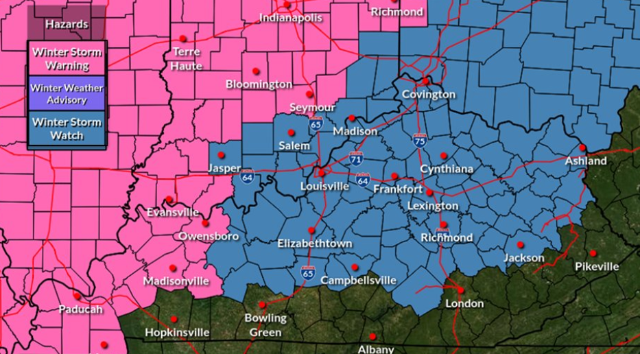
Good Tuesday night, folks! We continue to track a significant winter storm that is locked in on the Ohio Valley. The National Weather Service has issued a Winter Storm Watch for much of our area, and they will issue Warnings and advisories at some point tomorrow for much if not all of the state.  


Im still not confident in when things will changeover to frozen precipitation, but here is an approximate timeline: 

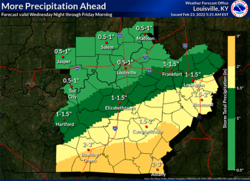
Tomorrow through tomorrow night: All rain, rainfall amounts between 1-2 inches are possible. 

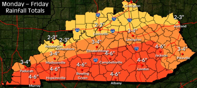
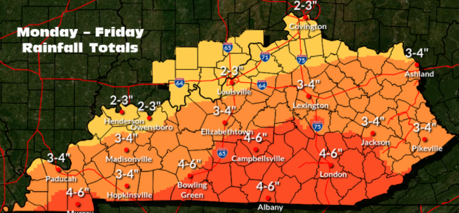
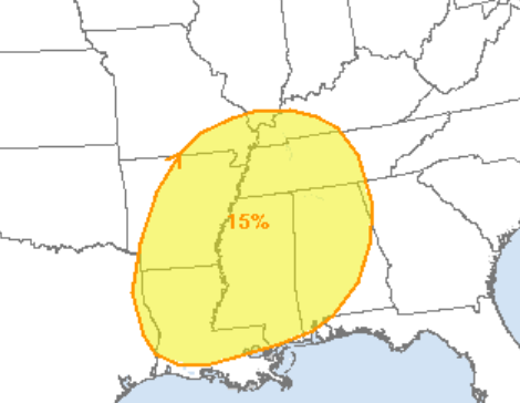
Rainfall amounts of 2.75 to 3.5 inches are expected across the region with isolated higher amounts. 

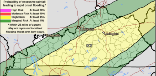
This amount of rainfall is expected to create excessive runoff, resulting in localized flooding in some areas.

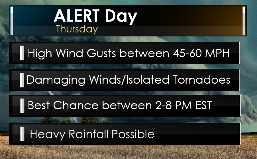
Thursday:  Arctic Front will slowly progress across the state from Northwest to Southeast, with temperatures dropping roughly 20-25 degrees. Rain will change over to Freezing Rain/Sleet throughout the day. 

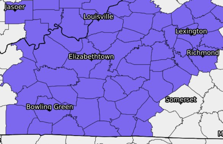
Here is an approximate timeline of when the changeover to frozen precipitation would occur: 

Louisville: 7 AM-12 PM 

Lexington: 3PM-9PM 

Elizabethtown: 10 AM-3PM 

Campbellsville: 6 PM-10 PM

Bowling Green: 7 PM-11 PM

This is a very approximate timeline, and this WILL change. 

Thursday Night through early Friday morning: All precipitation changes to Freezing Rain, sleet, and some snow before gradually tapering off early Friday. 


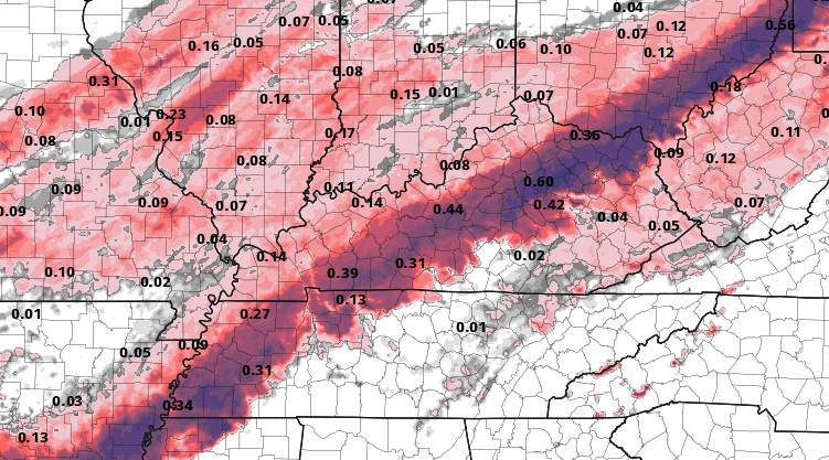
How much are we expecting? That's a good question, as the data tonight continue to differ on where the heaviest amounts of Ice will fall. It all depends on the exact track and how fast the arctic air moves into the state. If it's faster, we can expect more Ice. If it's slower, we will see more rain and minimal wintry precipitation. 

Here is the latest model data for tonight. 

NAM Potential Ice Accumulation:


NAM 3K Potential Ice Accumulation:


RDPS Potential Ice Accumulation: 


GFS Potential Ice Accumulation: 


I am monitoring the latest information. In the meantime, here are some essential tips from Mark Jarvis, Lead Forecaster at NWS Louisville. 
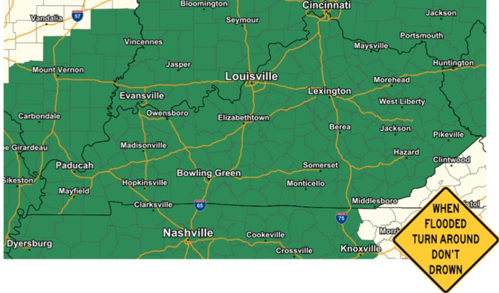
Now is the time to activate your winter storm plan. Make sure you have your usual staples. Fill up the car, get meds, etc. There is the possibility of power outages, especially if we get into higher icing amounts. If using a generator, keep it outside! Travel will become just plain bad by late Thursday afternoon. Periods of impossible travel may develop Thursday evening in some areas. 


On Air Now

Regular Programming
12:00am - 9:00am
Regular Programming

CNN News

Entertainment News

Twitter