THANKS FOR RUNNING' WITH THE BIG DAWG!
CATCH
WAKE UP WITH LARRY SMITH AT 5 A.M. FOR “MORNINGS ON MAIN” ON 99.9 THE BIG DAWG!

Forgot Password

Not a Member? Sign up here!

BIG DAWG WEATHER Archives for 2022-07

Flood Watch Now in Effect

The Big Dawg Weather Blog is presented by:

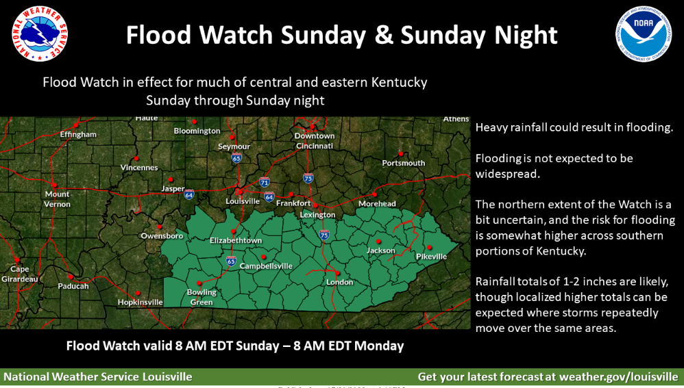
Flood Watch is now in effect from Sunday Morning through Monday Morning. Excessive runoff may flood rivers, creeks, streams, and other low-lying and flood-prone locations.
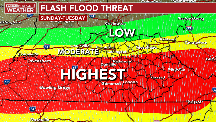
Periods of showers and thunderstorms are expected across the watch area. Rainfall rates of 1-2 inches per hour will be possible and bring a flash flood threat to central and southern Kentucky Sunday and Sunday night portions. Areas that see repeated rounds of thunderstorm activity will be most susceptible to flash flooding. You should monitor later forecasts and be alert for possible Flood Warnings. Those living in areas prone to flooding should be prepared to take action should flooding develop.

Flooding Threat Set to Increase Again

The Big Dawg Weather Blog is presented by:

Good Friday Afternoon, Folks! Parts of Eastern Kentucky have witnessed historic flooding over the past few days, and they are still on guard for additional flooding today through Tuesday. Most of the state will see the flood threat increase again, beginning Saturday night Through Tuesday. Showers and thunderstorms are expected to increase in intensity on Sunday. Multiple rounds of persistent heavy rainfall could cause isolated flooding concerns. WKYT in Lexington has highlighted much of Central and Southern Kentucky for the highest Flooding threat Sunday through Tuesday! We will keep you updated over the weekend, but it's important to stay weather aware, especially if you live in flood-prone or poor drainage areas! 

Flash Flood Threat from WKYT 


Hot Weekend on the Way

he Big Dawg Weather Blog is presented by:

Good Afternoon, Folks! Well-above normal temperatures are expected Saturday and Sunday. High temperatures will approach 100 degrees both days, with maximum heat indices likely to exceed 105 degrees. Prolonged exposure to this level of heat can pose health dangers, including heat exhaustion and heat stroke. If possible, limit time spent outdoors these days, and be sure to remain hydrated at all times.

Heat Wave with Severe Storm Threat

The Big Dawg Weather Blog is presented by:

Thunderstorms will be possible for much of this week, especially in the afternoon and evening. The main threats will be torrential rainfall, locally gusty winds, and lightning. The Storm Prediction Center has placed our area in a Marginal Risk (Level 1/5) for severe weather tomorrow and a Slight Risk (Level 2/5) for Wednesday. In addition to the storm chances, a combination of heat and humidity will create heat indices rising above 100 degrees, mainly from Tuesday through Thursday. As always, we will be watching things closely here in the Big Dawg Weather Center and will keep you updated with the latest. 

SPC Severe Weather Outlook for Tuesday    

SPC Severe Weather Outlook for Wednesday 

Drought Information 

Rainfall Potential Next 84 Hours