THANKS FOR RUNNING' WITH THE BIG DAWG!
CATCH
WAKE UP WITH LARRY SMITH AT 5 A.M. FOR “MORNINGS ON MAIN” ON 99.9 THE BIG DAWG!

Forgot Password

Not a Member? Sign up here!

BIG DAWG WEATHER Archives for 2023-01

Winter Weather Potential Increasing

The Big Dawg Weather Blog is presented by:

Good Saturday Afternoon, Folks! I was planning to do a live video today, but the data is still rather messy; therefore, I decided to type up a quick blog explaining what we could deal with next week. The bottom line is that we will see multiple chances for wintry weather from Monday night through Thursday, with ice or snow accumulations possible.

Key Messages 

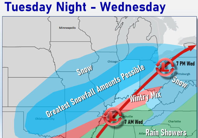
  • The best chance for Wintry Weather is on Tuesday, with more waves of wintry precipitation on Wednesday and Thursday. 
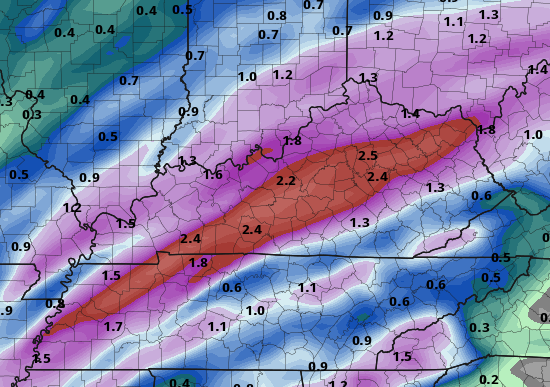
  • Ice accumulation is the main threat that we are looking at here in Central Kentucky. 
  • Amounts are still unknown, but even a little Ice can have significant impacts. 
  • Some snow is possible, but that will be mainly to our north. 
  • The Forecast will change over the next few days; stay tuned. 

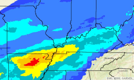
On Tuesday, the NWS highlighted Central Kentucky with the greatest potential in Louisville's area to see impacts from potential Ice accumulations. 

I will provide updates more frequently over thew weekend, and I will provide a LIVE video tomorrow to address all the newest data. Stay weather aware over the next few days! 


Wintry Weather Increases

The Big Dawg Weather Blog is presented by:

Good Monday Evening, Folks! An area of low pressure is expected to pass over the state Tuesday night, bringing precipitation chances to our area. As of this blog post, a wintry mix is possible tomorrow night, changing to rain during the day on Wednesday. The best chances for accumulating Snowfall through Wednesday will be along and north of the Ohio River. Additionally, gusty winds of 30 to 40 mph will be possible during the day Wednesday.

As we progress into Wednesday Night and Thursday morning, temperatures will drop again, changing rain to snow. Snow squalls are possible across the state, producing a quick half inch of snow with any snow squall. Ill be monitornig things closly over the coming days, stay tuned! 

Another Active Weather Week Ahead

The Big Dawg Weather Blog is presented by:

Good Sunday night, everyone! We will look at two waves of rainfall this week, with the first coming tomorrow night into Tuesday. Showers and a few thunderstorms will bring heavy rainfall again on
Wednesday night, especially across south central Kentucky. Rainfall amounts up to 2 inches could result in localized flooding of low-lying areas, and subsequent river flooding.

The latest GFS model is showing 2-3 inches of rain possible before the week is over. 

GFS Forecast Rainfall through Thursday Night 


As aways, Ill be monitoring this weeks weather, and Ill provide updates as needed! Have a great week! 


Storms/Snow Likely Thursday and Friday

The Big Dawg Weather Blog is presented by:


Good evening, Folks! Scattered showers and thunderstorms are expected early tomorrow morning and lasting into the early afternoon ahead of a cold front. A few of the storms may become severe during the morning hours. The main threat with severe storms will be isolated damaging wind, brief heavy rainfall, and possible hail. A tornado or two cannot be ruled out either. This isn't a significant severe weather threat, but we must watch any severe threat closely. The SPC has placed the entire area in the lowest severe weather risk. 

SPC OUTLOOK


Temperatures will drop Thursday night, bringing scattered snow showers to the area on Friday. Minor snow accumulations under 1 inch are possible at this time, but Ill keep an eye on this. 

Ill be monitoring things closly, stay tuned for updates! 

Storms/Rain Likely Next 48 Hours

The Big Dawg Weather Blog is presented by:


Good Evening, Folks! I wanted to give everyone a quick update on what to expect over the next 48 hours! Multiple rounds of showers and storms will impact the region late tonight through early Wednesday morning. 

Tonight

Isolated instances of severe weather will be possible during the overnight period. If severe weather does occur, damaging straight-line winds are most likely in the storms, with small hail and an isolated tornado possible. However, tonight's severe threat is extremely low. The SPC doesn't have our area at risk for severe storms tonight. 

Tuesday 

Storms will continue throughout the day on Tuesday, and below is the latest breakdown: 

  • One round of showers and a few storms Tuesday morning, then another round late Tuesday night.
  • The best chance for storms Tuesday night is between midnight and dawn.
  • Damaging straight-line winds, small hail, and an isolated tornado are possible.
  • Outside of storms, gusty southerly winds of 30 to 40 mph will be possible Tuesday.
  • Minor flooding may develop in spots that see the heaviest rainfall.

The SPC does highlight our area for the possibility of severe weather, but again, it is a low risk. 

In addition to the severe storm threat, Widespread 1.5” to 3” expected with locally higher amounts. Localized minor flooding will be possible. 

As with any severe weather threat, we must always be on our toes. I'll be monitoring things closely and will give updates as needed! Stay tuned


On Air Now

Regular Programming
12:00am - 6:00am
Regular Programming

CNN News

Entertainment News

Twitter