


The Big Dawg Weather Blog is presented by:
- A-Plus Comfort Care
- Central Ky Construction & Concrete
- Razed Right Barbershop
- Insulation Solutions of Ky
.PNG)
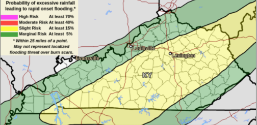
Good Tuesday night, folks! Wednesday will provide a brief break, with partly sunny skies and highs in the middle 40s. Our next system will move in Wednesday night and continue through Friday. Additional rainfall between 1-2 inches is likely, resulting in isolated flooding, especially over south-central Kentucky. Below is the Excessive rainfall outlook from the WPC, which slows a slight risk for excessive rainfall across portions of central and eastern Kentucky. Slight risk means that there is a 15% chance of localized flooding within 25 miles of any point inside the yellow.
Wintry Threat?
Looking ahead toward the weekend, model discrepancies remain. The GFS wants to bring a wintry system across our area Saturday night into Sunday, while other models like the EURO show a drier solution. If we see impactful wintery weather here this weekend, I have to see a higher consistency in the model data. We will see what the data shows over the next few days, but im not very confident at this time. Stay tuned.
.png)