


The Big Dawg Weather Blog is presented by:
- A-Plus Comfort Care
- Central Ky Construction & Concrete
- Razed Right Barbershop
- Insulation Solutions of Ky
.PNG)
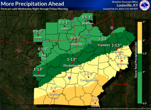
Good Wednesday Evening, Folks. Not much has changed in the forecast. Light precipitation is expected to move into the area later tonight and Thursday morning. As surface temperatures drop near or below freezing portions of north-central Kentucky, may see some freezing rain and sleet mix in. Slippery road conditions will be possible in that area, especially on bridges and overpasses. Here in Central Kentucky, some sleet or ice will be possible, but no impacts are anticipated at this time.
Another round of moderate to locally heavy rainfall will be possible across south-central Kentucky Thursday into early Friday morning. Additional rainfall amounts of 1.5 to 2.5 inches will be possible, resulting in additional threats of flooding. The National Weather Service has issued another Flood Watch for much of the area, effective until Friday morning. As always, Ill be monitoring the weather, and will provide updates as needed!
Precipitation Forecast
.png)